 Date and Time of Origin:19:00:46.9, on May 30, 1935 (UTC time and date); 02:33 A.M. local time (PST) on the 31 May 1935 (local date).
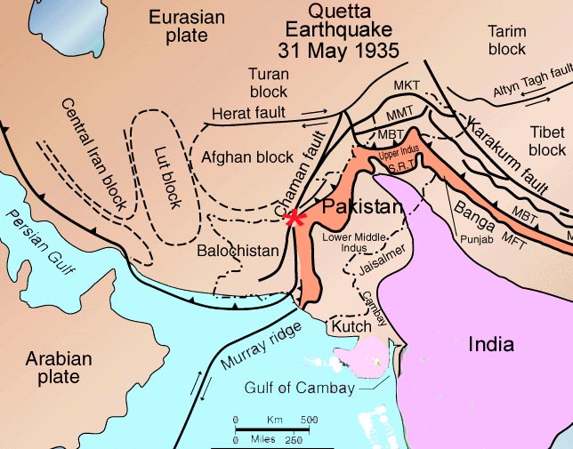
Epicenter: 27.39N, 88.75E, about 4.0 km SW of Ali Jaan in the Balochistan region of present day Pakistan.
Magnitude: There have been several reported magnitude value . A Moment Magnitude (Mw) = 8.1 asssigned to this event may have been an overestimate. Based on geometric seismic moment, the moment magnitude (Mw) of this earthquake was revised to range from Mw 7.7 - Mw 7.8.
Seismic Moment: 0.35*10*21 Nm, 0.63*10*21 Nm, 1.75*10*21 Nm.
Focal Depth: 17 kms.
Afteshocks: No foreshocks preceeded the main shock. The largest aftershock with magnitude Mw 5.8 occurred on June 2, 1935. It caused additional damage to Mastung, Maguchar and Kalat, but none at Quetta. Many smaller magnitude aftershocks followed in the region up to to October 1935.
Felt Reports and Ground Motions: The main shock was most intense in a small region surrounding the epicenter but its intensity diminishing rapidly with distance. According to reports, the shaking lasted for about three minutes. Widespread liquefaction was observed in the valley to the northwest of Quetta. Mud volcanoes erupted in this area, as well as near the village of Thok, near Surab. The eruption of the mud volcano at the latter location lasted for about nine hours.
The earthquake's ground motions were felt throughout present-day Pakistan, from Jatti in the south near Karachi, to Dera Ismail Khan in the north, to Chagai in the east, to Amritsar and Shimla, and as far away as Agra and Sultanpur in India andAfghanistan.
 Surface Rupture and Crustal Dislocations
According to surveys carried out after the earthquake, there was no evidence of uplift along the thrust faults to the southwest of Quetta. However, to the west of the town,uplift of 20 centimetres was observed. The ground deformations ranged from 2-20 centimeters, mostly observed as cracks in alluvium deposits. The cracks extended for about 105 kilometers from the south side of the Chiltan range to Kalat. Ground dislocations on the western side of these cracks near Mastung,indicated uplift of as much as 80 centimentres on the average,while in some places the ground had raised up by as much as several meters. Near the Mastung Road train station the observed cracks ran across the Quetta-Nushki railway lines and had caused vertical deformation and offset or the tracks. The ground deformations indicated that the Quetta earthquake was associated with the zone of faults that runs along the eastern edge of the Chiltan range and extends south toward Mastung and Kalat. Based on these surveys it was concluded that the Quetta earthquake occurred on a strike-slip fault within the Ghazaband Fault Zone, along a segment that may have been stressed by the previous 1931 Sharigh and Mach earthquakes in the same region.
Death Toll and Damages
According to the same reports and surveys, all villages between Quetta and Kalat were destroyed by this earthquake and about 70% of the population had died or were injured. The majority of the fatalites (about 26,000) occurred in and around the town of Quetta. There was extensive destruction and collapse of government buildings and most of the people in the city's administration were killed. There was extensive damage to hospitals and hangar facilities at the airfield of the Royal Air Force Lines, where aircraft were damaged and became inoperative. A few of the reinforced concrete structures and a new railway stations fared better and suffered minor damage.
The infrastructure of the region was severely damaged. Communications from Kalat and Quetta to Chaman and Jacobabadwere disrupted due to damage of telegraph lines. There was partial disruption of electrical service in Quetta, but the water supply continued uninterrupted. Rescue operations and clean up and salvaging by the military helped prevent major looting following the disaster. Prompt mass buials and cremations of the dead helped prevent the outbreak of an epidemic.Transportation routes were not badly damaged, though five segments of the Quetta-Nushki railway track had to be replaced as they were crisscrossed by fissures.
Mastung, another city south of Quetta, was severely damaged along with the Khan's palace. About 1,736 people reportedly were killed in this town. Similarly, the village of Sariab was flattened and 1,206 of its inhabitants lost their lives. There was extensive destruction at the village of Kansi where 1,010 people were killed. Another 710 people were reportedly killed at Tiri and 369 more at Pringabad. At the town of Kalat the destruction was severe and 120 people were killed. Overall, in the state of Kalat and in the Kalat tribal area, a total of 8,410 deaths occurred were reported with 5,000 more as injured. Nearly 100 villages in this region were devastated. Though the total number of fatalities from this earthquake are rough estimates, it is estimated that at least 35,000 peopleand perhaps as many as 60,000 may have been killed, which would make this earthquake the deadliest, up to that time, in present-day Pakistan' history. Also the damage, was widespread outside the immediate region. Poorly-constructed buildings as far away as the Indus Valley and Kandahar and Spin Boldak in south-eastern Afghanistan were repertedly damaged.
 Jinnah Road After Earthquake.


No comments:
Post a Comment